Tidbits of Shelby County History
District of Tenehaw
This week’s article is still being taken from the booklet written by Bennie E. Nix.
Early-Day Field Notes of Shelby County
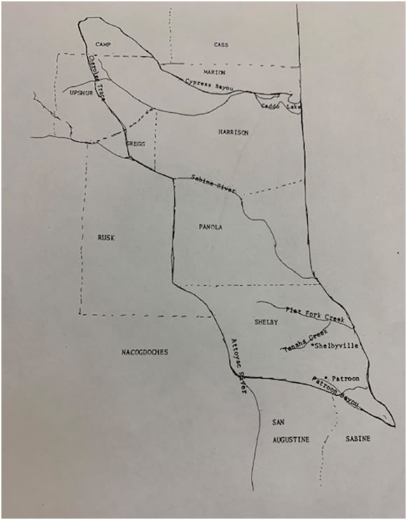
Art. 404 – Shelby (originally Tenahaw).” Beginning at the mouth of the small bayou which empties intothe Sabine River, just below the town of Hamilton, and running up that bayou to the crossing of the roadleading from Hamilton to San Augustine; thence on that road to a point opposite Buckley’s; thence on adirect line, including Buckley’s house, to a house lately built by J. Rowe; thence on a direct line to a pointrighton the road leading from J.M. Bradley’s to San Augustine; one and a half miles distant from saidBradley’s’; thence on a direct line to Kerr’s Ferry on the Attoyac River; thence up that river to its source,or to the crossing of Trammel’s trail; but if the said trail should cross above the head-waters of thatriver, then the said line shall run due west from its head-waters to said trail; to the Cherokee crossing ofthe same; thence on the road leading to Jonesborough to the Big Cypress bayou; thence down thatbayou to lake Soda; thence east to the boundary line between this republic and the United States of theNorth; thence along said line sought to the Sabine River; thence down the said river to the beginningpoint”.
“323. See also San Augustine, act of 14 th Dec. 1837. In regard to northern line, see Red River, act of 18 thDec. 1837. For change of northern line, see Harrison, act of 28 th Jan. 1839. For the line on the west, seeRusk, act of 16 th Jan. 1843; see also Rusk, act of 31 st Dec. 1844, and act of 1 st Feb. 1845. In regard to lineon north, see Panola, act of 30 thMarch 1846. Jurisdiction extended over the western half of the SabineRiver, so far as it forms the eastern line of this county. See act of 24 th Nov. 1849, Vol. 12, p 4. See alsoSabine County of the act referred to. Resolved, “That the district of Tenehaw be set off into amunicipality, and that the town of Nashville be the seat of justice.” No record can be found of theboundaries of this district, but it is believed to have been in the municipality of San Augustine, and thename of the municipality of Tenahaw be, and the same is hereby altered and changed to that of Shelby,and that all acts hereafter passed, and business done, shall be in the name of the municipality of Shelby.”
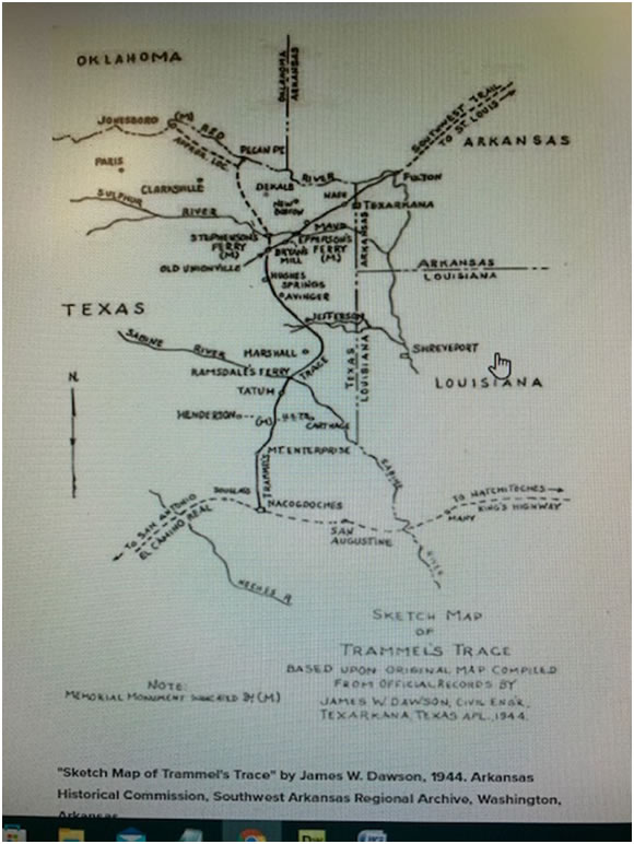
The District of Tenehaw (Shelby County) once covered much more territory than this county nowembraces. The Big Cypress herein mention is near Jefferson, Texas. The “Nashville” referred to was thename once given to present day Shelbyville.Buckley’s house is mentioned. This was John and Elizabeth Buckley and family listed on the “First Censusof Texas 1829-1836. The old Buckley home site and family cemetery are located near Pleasant Hillcommunity, and the cemetery is one of the oldest in Texas. John Buckley was one of the earliest Anglo-American settlers in Shelby County; not the first but came soon after the first.The “Trammel trail was “Trammel Trace”, one of the old trade and travel routes of Texas. The old“Trammel’s Trace” road extended from Gaines Ferry or Pendleton Ferry near Milan, Texas, throughShelbyville in Shelby County, out through Newburn community,(Note: none of the maps I researchedshowed Trammel Trace in Shelby County) and on through Jefferson, Texas and into the Arkansasterritory near Fulton, Arkansas. “Trammel Trace” made connections with all roads leading west. It wasmentioned by Mr. Middleton in his “Regulator-Moderator” story. At Pendleton’s Ferry it madeconnections with Camino Real or the old San Antonio Road coming through Natchitoches, Louisiana onto Mexico by way of San Antonio, Texas. (Note: Trammel’s Trace was the second major route intoSpanish Texas from the United States and the first route from the northern boundaries along the RedRiver. In the early 1800’s Trammel’s Trace was a smugglers’ trail, but later became a path forimmigration to Texas. It was an historic corridor connecting travelers from Kentucky, Tennessee,Missouri, and Arkansas with the El Camino Real at Nacogdoches. Remains of “Trammel’s Trace” can befound in Bowie, Cass, and Marion, Harrison, Rusk, Panola, and Nacogdoches counties in East Texas. Itextended into Little River, Miller, and Hempstead County, Arkansas but the terrain there is not conduciveto preservation of road ruts. The Great Bend of the Red River at Fulton, Arkansas is where “Trammel’s Trace” connected with the Southwest Trail across Arkansas.)
According to Bennie Nix, stagecoaches came over Trammel’s Trace and that Sam Houston and DavidCrockett came to San Augustine over this over road.
Note: I am enclosing two maps one that shows Shelby County’s boundaries when it was established as a county in 1836-37 and the other is of Trammel Trace.